May 3, 2007 at 6:38 a.m.
Recent low-flying planes were part of digital mapping effort documenting county
Recent low-flying planes were part of digital mapping effort documenting county
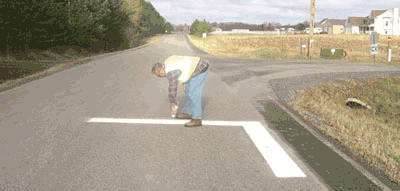
County Surveyor Terry Johnson was prepared to act quickly as soon as the snow was melted. His job would be to position large "targets" at survey intersects all over the county, which would serve as direction-markers and elevation points directing a specialized airplane and crew in creating a half-million-dollars' worth of aerial photos and contour mapping.
Mother Nature's window allowing this aerial data collection runs only from the moment the ground is totally clear of snowcover until leaf-out, maybe two to three weeks. There can't be water standing in ditches because that'll give a false elevation readout, so the project needs to happen before any heavy rains. A major grassfire can also ground a mapping flight, which was the case around April 18 when smoke was hanging here from a spate of west Wisconsin fires.
Surveyor Johnson tasks were part of the contract with a firm from the east coast, Optimal Geomatics Inc.
You might have spotted the Optimal Geomatics Inc. plane criss-crossing the county, wondering if it had lost its way, or if it was just a crop duster minus its dust. The plane was following the section lines and taking cues from Johnson's ground targets that he laid either using white paint on hard surfaces or by laying old washroom handtowel rolls, folded into an L-shape or cross pattern where painting targets would not be feasible.
He had to set a Global Positioning System elevation accurately attributed to the target. From there a signal sent from the plane to the ground would translate back into lines on the images showing as topography changes as minor as one-foot.
The hard part now is waiting for the finished product. "The soonest the county will be able to see data is August," Johnson explained. The actual set of digital images won't be delivered until probably February 2008.
The County Board approved the $522,000 expenditure (4-1 Montzka opposed) back in December. The project was presented to the Board as a valuable tool for a number of county departments. The county will also sell the data.
Assistant County Engineer Joe triplett said at an estimated $7,000 to $10,000 cost per mile to hire out individual projects the county's already spent some $200,000 on aerial information gathering on about 29 miles of road projects. "The Transportation Improvement Plan, through 2012, has around 29 miles of reconstruction. This would cost another $203,000 to $290,000. That means from 1999 to 2012 we could spend anywhere from $406,000 to $580,000 collecting surveying data for 58 miles of highway." Triplett added, "What we are looking for is to spend that money to purchase this information for the entire county as well as the 375 miles of roads, for the ($522,000) and not just 58 miles of road."
MnDOT is contributing $25,000 to have access to some of the raw data. Local cities are expressing interest in buying the images too. Developers and other agencies could also be potential customers. The County Board was told that already almost $100,000 of the initial expense is coming back to the county in the form of commitments for accessing this information.
These digital documents can be used for hydrologic and drainage data, for culvert and ditch work, wetland identification, for laying out road projects and any number of activities. The detailed photography will help building inspectors do their jobs, or aid in code enforcement.
Johnson explained Optimal Geomatics Inc. flew the county at approximately 3,900 feet. The flights went at night and during the day. The contour mapping relies on a pulse sent to the ground so those could be shot at night. "There's actually less interference at night," Johnson said of the signal path.
Chisago County is also taking delivery of photos-- "planametric" images-- which will be of fine enough detail to count sheep in a pasture, the County Board was advised.


Comments:
Commenting has been disabled for this item.