March 6, 2008 at 7:45 a.m.
Wyoming Township and city present Comp Plan to citizens
Wyoming Township and city present Comp Plan to citizens
Consultant Bill Weber said the Comp Plan "really is a plan for a single government unit" to administer and he expects final plan adoption after consolidation of the township and city sometime this summer.
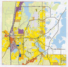
According to the work that was presented the Wyoming "city center" remains at the intersection of Viking Boulevard and Highway 61 (County Road 30.) Areas identified as suited for additional commercial development elsewhere in the township-city region have also been identified in the plan.
The comp plan proposes a couple of new major collector streets, such as Innsbruck Avenue, which now stops at #36, to extend fairly straight south to Wyoming Trail (County Road 22). Extending Goodview Avenue a short distance across #22 to connect to Viking Blvd. is another collector route improvement proposed.
New streets are also shown in the hoped-for southeast corner of the united Wyoming City, but it hasn't been decided if this area will be annexed, as it's part of the contested boundary with Chisago City.
The plan identifies the new combined city's shoreland overlay zoning district, which falls under shoreland management state laws. This is a strip approximately 1,000 feet buffering most lakes and 300 feet along rivers. Special setback and construction considerations are in effect along these overlay areas.
There's a light industry and general business use shown abutting the Carlos Avery wildlife area, generally where the closed and covered landfill is now located.
Industrial- general business is also shown at the Xccent parcel proposed on the south end of town, by the freeway, plus there's industrial-general business all along I-35 from Wyoming downtown to Stacy.
Task force members also declared areas where city sewer and water should become available in the long term (shown in bright yellow on graphic) so developers and property owners can plan accordingly.
Trails, parks and open space are on the plan. A new trail is shown alongside the new collector street that will run south from Innsbruck, it isn't determined if this would be an off-road trail or an extra wide shoulder.
The Swedish Immigrant Trail is shown on the comp plan alongside #22 or Wyoming Trail. Earlier proposals put this trail within a former railbed corridor north of Viking Boulevard, passing near the Polaris Technology facility; but due to cost considerations and in order to place the east-west trail somewhere on the plan, city engineer Mark Erichson said it's shown as part of Wyoming Trail.
No site is identified for a citywide athletic complex. Planners expect a special study for a project like this after consolidation of the township and city.
This land use plan will be introduced in hearings later this month before an administrative law judge who is to rule on the contested portions of the township and city annexation petition. The comprehensive plan is necessary to illustrate that Wyoming is prepared for future growth and accommodating the population's needs.
A Comp Plan is not a legal zoning tool. Ordinances must be enacted to enforce specific items that the plan only advises.


Comments:
Commenting has been disabled for this item.