February 3, 2011 at 8:19 a.m.
Chisago County leading pack on available data about geo-resources
Chisago County leading pack on available data about geo-resources
The Geologic Atlas of Chisago County is Part One of a two-part reference tool being put together. Part Two will be completed in a couple of years and will provide details on the county's water resources.
Dale Setterholm, Minnesota Geologic Survey Project Manager, presented the atlas to about a dozen interested citizens last week in a special evening program at the Chisago Lakes Area Library.
Setterholm said it has taken 30 years to produce a geologic atlas for 21 counties. However, with new infusion of funding through the Legacy Amendment (voter-approved sales tax) and with continued support from the Environmental Trust Fund (lottery proceeds) there are now geologic atlas projects operating in 11 Minnesota counties.
The atlas is available through Jerry Spetzman, water plan coordinator at Chisago County. You can access it in paper form, or you can purchase the compact disc of the same materials. Setterholm mentioned various types of software that can be applied to the data to allow the user to overlay information and even create three-dimensional views of the county's geologic structure. "You can make the map you want to use," he told the attendees at the information meeting.
Setterholm took lots of questions about local aquifers and sustainable quantities of water, how water recharges itself and about locations of certain soils.
Two "faultlines" that have been identified (in North Branch and through Wyoming) are not monitored for seismic activity by officials. They provide for a "barely perceptible displacement," he added. Should there ever be anecdotal reports of seismic activity; in Minnesota the DNR is prepared to send out questionnaires to affected residents and survey "earthquake" activity.
Setterholm said cities looking for a new water well site will find the geologic atlas data useful. The cost for creating the whole atlas is less than what one city could potentially waste drilling in an unsuitable spot for a well.
Other atlas users may be looking for underlying geologic data for a development or single homesite. There's also hundreds of individual wells on the map and information about their depth and soils encountered.
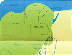
The atlas includes five cross-section illustrations as well. Setterholm said this is not accurate to a tiny location, but the cross sections give the most-educated guess by geologists as to what lies beneath us. The "slices" are taken horizontally, starting at the south end of the county at Wyoming- straight east to the St. Croix river, at Stacy, to the Wisconsin border, from North Branch city center, east to Wisconsin, from the county border at Harris to Wisconsin and also straight across the county through Rush City. (See graphics.)
Maps can be generated showing sand deposits, gravel deposits, how far to bedrock-- and other geologic details.
Setterholm said this is useful when determining a site's sensitivity to pollution. The data can be made into a digitized spreadsheet, for example, that can simulate adding certain number of new wells, for instance, and the computer will determine the effects of the wells on aquifers. The map of existing well sites, (compiled from well driller reports) shows how deep and where they are, and is fascinating.
Setterholm said the county is lucky to be where a sequence of sedimentary rock was put down when the earth was forming here billions of years ago. Chisago County was repeatedly covered by ice sheets carrying debris.
The county is located in what geologists call the "Grantsburg Sublobe."
Setterholm said after the final retreat of the "Superior Lobe" (all related to glacial activity) this sublobe carried in debris from which Chisago County derives its distinct material content.
Two major bedrock aquifers stretch across Chisago County. Setterholm said modeling has shown that some counties in the metro area are rapidly consuming their immediately available sources of water, while outstate the water consumption is more like 10 percent of what's available.
There also needs to be more analysis on the impacts regionally to taking water from one point, but not re-introducing it back near its source (ie: industrial consumption.) Setterholm explained that his home's individual septic system basically takes water from the well, he uses it in his dwelling and then it works its way back into the ground through a wastewater system in the same immediate area. More needs to be learned about the effects of large quantities of water resources moved out of originating locations, versus where this water is re-introduced.
And, to close the session at the library on a fun note: the computer displayed on the powerpoint screen-- a simulated three-dimensional "flight" upriver inside the St. Croix River Valley, using cross sections geologically pieced together and then linked.


Comments:
Commenting has been disabled for this item.